Fort Cabo de Rama , Goa- A Fort that never witnessed a war
History and legend of Fort Cabo de Rama, Goa
 |
| Fort Cabo de Rama |
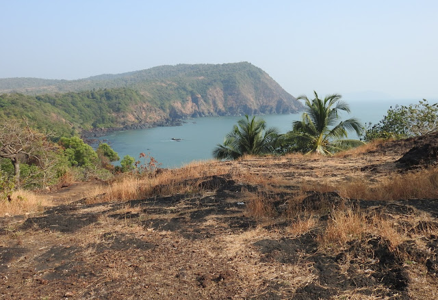
My JourneyGoa is known for its beach and casinos. But, this stretch of land, sandwiched between the Arabian Sea and the Western Ghats, also harbors many rock art sites, prehistoric monuments, Buddhist caves, temples, and historical monuments etc with rich history. After visiting a prehistoric rock art site at Panacimol, Mr. Andrew Lewart (a British Scholar) and I were driving downhill to Canacona beach through a barren hillock in Cola Village . It was during the last few days of tropical winter. For miles, all around, the laterite outcrop of the hillock wears a golden carpet of dry grasses. Trees seldom appeared, apart from some isolated patches of cashew trees. Herds of Brahmin cattle were roaming around the grassland desperately searching for greens. Brahman cows of Goa have a close resemblance with dwarf cattle of Malanad. This cow seems to be representative of cattle depicted in Goan rock arts. Alas!!! hills meets the seaAll of a sudden the scene changed and turquoise blue sea appeared
beneath the cut edge cliff of the hillock. A glossy green line of
coconut palms along the windy coastline can be seen from the brink.
A road turning left at this point leads to a ruined fort called
'Cabo de Rama'. Though Goa has 11 Forts within 160kms of coastline,
the name of this particular Fort appears attractive, because the
rest of the Forts carry Portuguese names, but this Fort is named
after epic hero Rama. The cape where the fort is located is called
cape of Rama. The Portuguese usually named their monuments after
their saints, even the ones they captured. Cabo de Rama is a
lesser-known tourist attraction in Goa and you won't find details of
this Fort from a tourist guide book. But it is a fantastic location,
very beautifully placed in a cape having a fabulous 280-degree view
of the sea. After nearly a kilometre drive, we reached the Fort
Gate. GOA - land of Forts
Truly Goa is a land of Forts. Eleven forts can be seen in 160kms of
its coastline. It shows the strategic importance of Goa on the west
coast in the medieval period. Construction of many of these Forts
started during the Bijapur sultanate. Fort Cabo de Rama, located
61kms South of Panjim city, is placed in a beautiful hillock
overlooking the Arabian Sea. Kholgad- a high headland presently known as Cape of Rama The hillock were the fort is situated was called Kholgad , before
it was named as cape of Rama. The site was known for its speedy
recovery from illness after a bath in two springs spout side by
side, but in two different temperatures. In ancient time the site
was known as a sanatorium for local people. There are records of
discovery of Neolithic Petroglyhs on the vast expanse of laterite
outcrops. The name Rama Killa was probably given by the Sonda King’s
period. As per popular legend , epic Hero of Ram spent few days here
in his exile.
Who built the Fort - Sonda ,Shivji or Portuguese?
As per legend the Fort was built by the Sonda King, a Hindu
feudatory of South Goa, but as per records it was built by the
Maratha King Shivaji in 1679. In 1675 Shivaji, attacked Ponda
, which was ruled by Sonda king. The Bijapur Sultanate administered
all their possession between Portuguese Goa and Karwar from this
defence point. After the conquest of Ponda, the rest of the
possessions of the Bijapur king south of Ponda came under Maratha's
rule. Shivaji, after the conquest of Ponda, ordered for the
construction of forts in strategic locations in his new possession.
Shivaji started the construction of a Fort in Kholgad, a bluff high
headland facing the sea, which was under the Sonda. The Portuguese
objected its construction but failed to stop Shivji.
The barren laterite cape hill overlooking the Arabian Sea is a
strategic location, which was probably used by the Sonda King for
defence purposes before the Maratha.
Cape of Rama was found a suitable place for a Hill and Sea fort. The
construction of the Fort started in 1679. Shivaji died in 1680
before the completion of the fort. Sambaji, son of Shiva continued
the construction of the Fort. The hostilities between Sambaji and
the Portuguese continued till the peace treaty signed in 1684.
Thereafter, the Marathas stopped the construction of Forts in
Portuguese territory.
Sonda was a Hindu feudatory that ruled South Goa after the
Vijayanagara period. Since 1675 the Sonda King was a feudatory of
the Mughal Empire. The territory between Canacona and Ankola was
given to him by the Mugal emperor Aurangzeb. Sondekar (Sonda King)
was a trader rather than a king. He changed his title between
Sultanate and Marathas. Thereby the Sonda king kept the Fort till it
was captured by Hyder Ali. In January 1764 Hyder Ali captured
possessions of Sondekar including Forts. Sonda King took
shelter in Portuguese territory. Though the King of Sonda had tried
to regain his territory from Hyder Ali, the Portuguese did not help
him. Hyder Ali wanted to keep good relation with the Portuguese
because of their enmity with the English. The Portuguese knowingly
suppressed Sonda King, because they wanted to annex South Goa to
Portuguese territory. At last, in 1771 Sondekar promised to
surrendered all his territory including forts to the Portuguese if
they helped him to regain his possession from Hyder Ali. The
Portuguese took a double stand and cheated Sonda King. In 1791
Portuguese annexed all possessions of Sonda including the Fort.
Thereby the Fort Cabo de Rama came under Portuguese rule. It was the
Protuguese who named the fort Cabo de Rama and subsequently
developed .Though the Fort came under many rulers, it never
witnessed any notable war. The Portuguese used this Fort for a few
more decades and then converted it as a jail till 1955. In 1962 the
Fort came under Indian Territory.
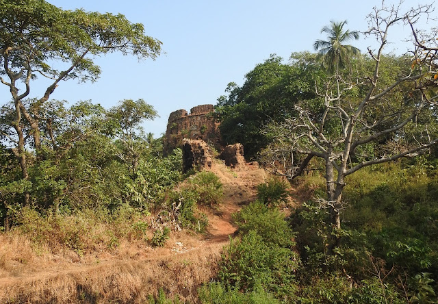
The Fort is completely built with laterite blocks. Kilometres long
Fort wall can be seen around the cape. The gate of the Fort is
facing North-East.
Total Area of the fort is 14, 5850 sq.Mts The Fort Wall has 5
Meters high and 1.6 to 1.75 Mts wide. The Fortification in Zig Zag
manner using locally available laterite blocks, lime mortar etc
After the entrance area, natural growth of wild plants invaded the
cape due to lack of maintenance. A Church, abandoned cannons, ruined
fort belts, ruins of few old structures, etc are the only monuments
inside the Fort. A walk along the belt of the Fort gives a beautiful
view of the sea and mountains. White-bellied sea eagle and certain
pelagic birds were perched along the cliff edge and rocky beach
line.
The walking trail along the old Crotchet(a passage around traverse
on the covered way) is ideal to enjoy the Fort. One can return to
the gate after circumambulation through the fort wall. More
than a historical monument, it is an ideal spot to enjoy the Ghats
and the Sea in one frame. It is an ideal spot to watch watching
pelagic birds. The coastline is very active with tiny fishermen
villages in the cliffs. A big quadrangular freshwater tank called
‘Tali’ is located in the north side. The laterite surface can
provide sweet water even though it is close to the sea. Probably
this lake was older than the Fort. The landscape of the Cape is
going high towards its west. The central area of the fort is
flattened for the parade ground. Two bastions and one demi-bastion
on can be seen in the crag of the west side of the cape. The curtain
(a section of a bastioned fortification that lies between two
bastions) on this side is short. There are two embrasures (openings
in a wall or parapet through which cannons fired) in this site. The
cliff is very steep on its seaside and makes it difficult for
enemies to approach the fort. Along with the curtain, there are many loopholes (a small opening
in a wall or stockade through which small arms were fired) and a
reverse fire gallery, facing slopes of the cliff. The curtain
(defensive wall) is set between demi- bastions of the Fort. After a
couple of hours, we finished our trail and returned to Fort Gate.
What attracted me most was its beautiful location; view of the sea
meets mountain and folks of pelagic birds. Two fishermen villages
placed on the cliff edges of the Cape are a fascinating view. There
is a small beach north of the Fort called Cabo de Rama beach. It is
undoubtedly a beautiful beach falls along a less-travelled
route.
ConclusionCabo de Rama
Fort is located 30kms from Margoa. This is an ideal spot to visit those who are
interested in off-the beaten tracks . The spot is ideal for lonely walks ,
cliff hikes, bird watching and to enjoy unique view of sea and mountain. Though
it is a lesser known fort , it is huge with marvelous fort architecture set
amidst Sea and Mountains. The Khelad hill is ideal for sunrise and sunset. It
is also ideal for people who are interested in Medieval maritime history of India. Who built
Cabo de Rama fort is a controversial topic
among historians. Research on this fort take me to many more conclusions about
its etymology, legends and history. As usual I have used ethno-archeological
approach to find facts apart from available written history. I am sure we need
more clarifications, and awaiting your response References :1. Pissularlencr
P Dr. : 1983 ; Portuguese Maratha Relations (English translation ) 2. Frederick
Charles Danvers, The Portuguese in India — Being the History of the Rise and
Decline of their Eastern Empire,
3. Portuguese Goa , Pp 337 to 378 |


CONTACT Mr DENNIS SMART call ( +2347036991712 or WhatsApp him through this number +2347036991712 or email: greatilluminatibrotherhood537@gmail.com Hello everyone My name is SOLOMON PRINCE Am from Liberia I am here to give a testimony on how I joined the illuminati brotherhood, I was trying to join this organization for so many years now,I was scammed by fake agent in south Africa and Nigeria,I was down,I could not feed my self and my family anymore and I tried to make money by all miss but all invail, I was afraid to contact any illuminati agent because they have eat my money,One day I across a post of someone giving a testimony, thanking a man called DENNIS SMART of being helping him to join the illuminati brotherhood, then I look at the man email and the phone number that was written there, it was a nigeria number I was afraid to contact him because a nigerian agent eat my $5000 and go away with the money then I was very tired, confused and I decided to contact the person that was given the testimony and i called him and I communicated with him on phone calls before he started telling me his own story about when he wanted to join, he told me everything to do, then I made up my mind and called the agent called DENNIS SMART and he told me everything to do, and I was initiated, surprisely I was given my benefit of being a new member of the great illuminati brotherhood I was so happy,For those of you trying to join this organization this is your opportunity for you to join CONTACT MR DENNIS SMART call ( +2347036991712 or WhatsApp him +2347036991712 or email: greatilluminatibrotherhood537@gmail.com
ReplyDeleteJOIN THE ILLUMINATI666 BROTHERHOOD?!!!
ReplyDeletecontact us on +2349017887682 or illumnatib53@gmail.com
Are you a business man, or woman,are you a pastor
or an artist,, do you want to be famous or you want
to be rich or powerful, it is better you become a
member of Illuminati and make your dream come
true . this is the chance for you now to become a
member of the temple KINGDOM and get what you
seek from us.if you are ready to become a member
of Illuminati and realize your dream then-: whatsapp
us or email
illumnatib53@gmail.com
fill in the following as well-:
NAME....................
NEXT OF KIN...................
ADDRESS.................
MARITAL STATUS.............
COUNTRY.........
STATE..................
OCCUPATION................
MOBILE LINE............
A NEW MEMBER WILL GIVEN THE SUM OF
120MILLION DOLLARS, A CAR AND A HOUSE IN ANY
PART OF THE WORLD. NOTE: WE ARE NOT FORCING
ANYBODY FOR THIS. IF YOU ARE NOT INTERESTED
PLEASE DON'T APPLY